Weather & Radar
Página de inicio / Artículos recomendados /

Level 3 out of 5: Severe storms could hug part of Gulf Coast

04:15 PM
24 de enero de 2023

Level 3 out of 5
Severe storms hug parts of Gulf Coast
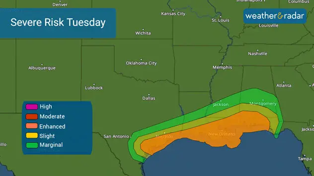
Severe weather threatens much of the northern Gulf Coast this Tuesday. The storm is the same system that's emerging from northern Mexico, increasing the threat for severe storms throughout the afternoon and into the evening hours from Texas through the far western portion of Florida’s Panhandle.

There is an enhanced risk, level 3 out of five, of experiencing severe thunderstorms that could bring damaging winds and tornadoes near the middle to upper Texas coast late this morning into the afternoon. The storms will continue to move eastward, ahead of a cold front, and threaten the coast of Louisiana, Mississippi, Alabama, and northwestern Florida.

Numerous severe storms are possible on Tuesday across the Gulf Coast from Texas through western Florida. Numerous severe storms are possible on Tuesday across the Gulf Coast from Texas through western Florida.

For Texas, the most active storms will remain focused along the coast, but cities about 50 -70 miles in, such as Houston, could see some isolated severe storms too. New Orleans should start experiencing severe conditions late Tuesday afternoon into the evening.

This is also part of the same system bringing rounds of heavy snow across parts of the Ozarks on Tuesday but the southern portion of the system, closer to the low-pressure center, will remain very close to the coast allowing the temperatures to stay well above freezing, at least for the meanwhile. The winds will directly hit the coast ahead of the storm and bring an influx of moisture which will feed the thunderstorms, many of which will be turning severe.

threatsSevere storms could produce damaging winds, hail and tornadoes.

In the upper levels of the atmosphere, there are also very strong winds rushing in through this same area which will bring the chance for tornadic storms as the winds will be rotating with height. Central Mississippi and Alabama should be aware that the threat of tornadoes is possible as there could be more moisture and wind shift with height in this area this evening and into the wee hours of the morning on Tuesday.

Once temperatures drop in your area, that will be your cue to know you are no longer at risk

Some severe storms could be moving over Alabama and NW Florida around midnight.Some severe storms could be moving over Alabama and NW Florida around midnight.

Make sure to have at least three ways of receiving weather alerts. This is the time to know where you would go to seek shelter if a severe thunderstorm or tornado warning is in effect for your area.

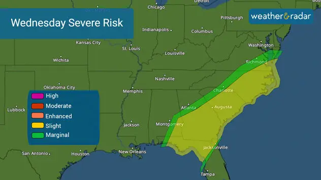
Wednesday's threat

The risk for severe storms, more isolated in nature will move east on Wednesday and likely affect parts of North Florida, Georgia, and the Carolinas.

Isolated severe storms with damaging winds and isolated tornadoes possible. Isolated severe storms with damaging winds and isolated tornadoes possible.
Irene Sans
9 de febrero de 2023
Severe Storms for the South

Wednesday's Live Blog

Severe storms aim for the South

8 de febrero de 2023
A strong winter storm will make travel difficult starting Thursday.

Starting before sunrise

Winter storm to interrupt Thursday plans

8 de febrero de 2023
Severe Weather Threat in the South

Turn your alerts on!

Severe weather threat in the South

Todas las noticias
Weather & Radar
Web | App
facebookinstagramtwitterContacto
US
Argentina
España
USA (English)
Protección de datos | Aviso legal